iLIANE: LiDAR aided Navigation Equipment - Geo Localization without any GNSS
Robust, self-sufficient localization with INS/LiDAR for vehicles also in GNSS denied environment
Robust, self-sufficient localization with INS/LiDAR for vehicles also in GNSS denied environment
With iLIANE, iMAR provides a setup for navigation and localization in GNSS denied environment. The system contains the optical system (LiDAR), the inertial system (iNAT), the data processor, the real-time processing software, the power conditioning.
Due to the sensor setup, iLIANE works in both day-light and night environment with the same performance. It s used for both to navigate within a 3D map without any need of GNSS and also to support the generation of a 3D geo referenced map. Navigation without as well as with GNSS is supported with high accuracy.
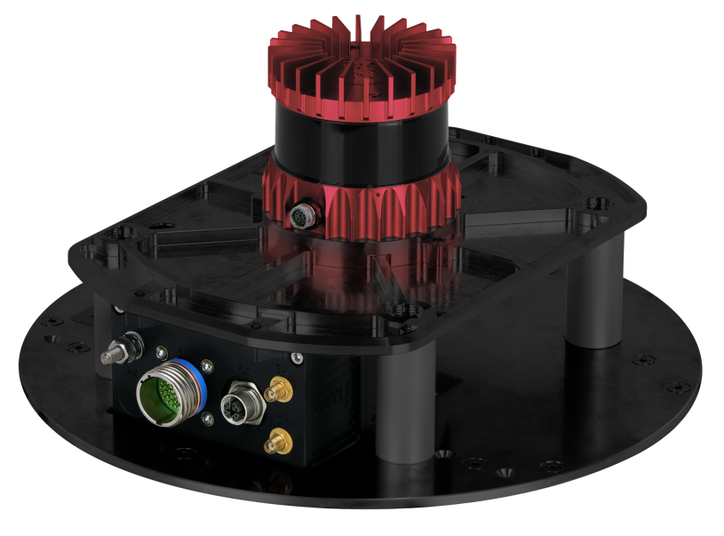
iLIANE features:
- small size, highly robust, easy to use "plug & play"
- operable on each vehicle’s roof
- internal LiDAR, IMU, GNSS receiver (all-frequencies / all-constellations, SBAS & RTK support, single and dual antenna support), wheel sensor interface supported if desired
- available with all class of INS performance, from MEMS over FOG to RLG based systems of series iNAT (commercial / industrial) and iSULONA / iCOMBANA / iPRENA (defence / protection)
- excellent accuracy also in operation without any GNSS and without any wheel sensor – 0.1 … 0.5 % distance travelled.
- Automatic map generation and capability to use this map during future travels. Map referencing capability to a definable Reference Frame (WGS84, ETRS89, UTM) for geo localzation. This feature is available in real-time, i.e. the vehicle will benefit immedeately from its own generated map or the map of another vehicle within a convoi.
- Capability to improve and adapt previous generated maps with each following travel
- iLIANE provides position and heading infrmation on roads and off-road, in urban canyons, within buildings, underground, in mining areas , in tunnels, on the battlefield (e.g. to secure vehicles in minefields) etc.
- excellent Ground Truth in GNSS denied environment
The accuracy without GNSS aiding is about 0.1 ... 0.5 % of distance travelled (without using a previously acquired map) and within sub decimeter range within a previously acquired map.