iCOMBANA: Combat Vehicle Navigation Solutions with Gyro Compassing Capability (dual-use equipment)
Low Weight Small Size FOG and MEMS based INS for Combat Vehicles
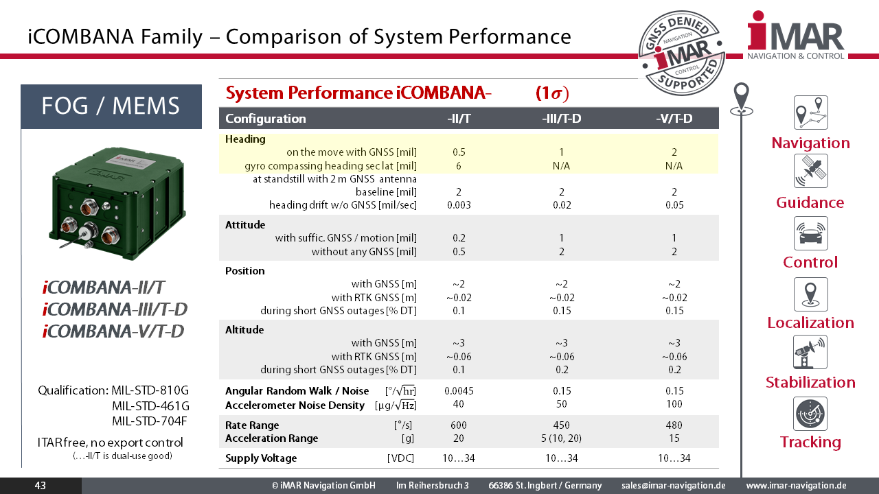
iCOMBANA is a family of light weight small-size accurate inertial navigation systems (INS), based on FOG and MEMS sensor technology, of class 0.01...0.1 deg/hr AllanVariance bias stability and 0.1...5 deg/hr bias performace over full temperture range, consisting of 3 robust fiber optical or MEMS gyros and 3 MEMS servo accelerometer axes, integrated GNSS receiver (GPS, GLONASS, GALILEO, BEIDOU), wheel sensor interface and an advanced 42+ state Kalman filter based INS/GNSS loosly or tightly coupled data fusion.
Important Information regarding phsical constraints of FOG based solutions on military vehicles for high performance navigation purposes: Fiber optic Gyroscopes (FOG) provide high angular resolution and can provide very low angular random walk (ARW). They find their application in platform stabilization tasks and in environments, where it is guaranteed by the application, that the vibration level is very low and no temperature gradients will occur (e.g. on unmanned and manned subsea vehicles). It is common knowledge and experience of users, that due to physical limitations of fiber optic coils (independent on manufacturer), the usage of fiber optical gyros is not recommended for precise navigation on military vehicles (significant remaining dependancy of the gyro bias on vibration and temperature gradients even after error modelling).
Due to the different design, the ring laser gyroscope (iPRENA family) - in contradiction to FOG systems - does not suffer of these impacts. Reason is the Zerodur monolithic block inside the RLG, which has a temperature coefficient of exactly zero. Therefore the RLG is the leading technology in front of vibrating and FOG based sensors for military vehicle navigation.
Features
- Applications: GNSS aided navigation (air, land, sea, subsea), attitude heading reference (AHRS), surveying, UAV, AUV and RPV guidance & control
- Real-time data output: longitude, latitude, alttude / height, velocty, roll, pitch, yaw / heading, angular rates, acceleration, status, calibrated raw data INS/GNSS (for post-processing)
- Interfaces: RS485 (UART) Interfaces, CANaero / ARINC825 / CAN, Ethernet (TCP/IP and UDP), ARINC429, SYNC-I/Os
- Data output rate up to 500 Hz (each data log separately adjustable)
- Integrated all-frequencies / all-constellations GNSS Receiver with RTK capability and dual-antenna heading support.
- designed to work also in GNSS denied environment, under spoofing and jamming conditions
- Interface to external wheel sensor to provide also full dead reckoning operation
- Gyro compassing capability (determines true north without any need of GNSS)
- Inertial Sensor and System Performance: see datasheet
- Integrated 42+ state EKF based sensor data fusion
- Internally up to 128 GByte non-volatile memory for data storage
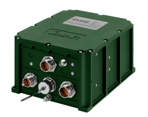
- Connectors: MIL-C-38999 III type and TNC
- Power Supply: 10...34 V DC, < 18 W
- Weight: approx. 5.5 kg; low SWaP
- Power supply and EMI-EMC protection qualified to MIL-STD-704F / MIL-STD-461G / MIL-STD-810G; partially designed to meet DO160G
- Modular system architecture: customized applications can be integrated by iMAR easily (please contact our sales for details). So the iCOMBANA can provide arbitrary data and command protocols according to customer requirement, e.g. to substitute other navigation systems by iCOMBANA (e.g. for Form-Fit-Function replacements)
- integrated all-frequencies / all-constellation GNSS engine; interface to external mil grade GNSS receivers (SAASM, M-Code etc.) like ERGR, NavHub, TopStar
- iCOMBANA is not subject to any ITAR control
Note:
In compliance with our proven design philosophy and our technical code of conduct for development, production, and quality assurance of our products and solutions, only physics determines the behavior of iMAR’s measurement systems. The real-time output of our systems and solutions in the inertial signal path is achieved through the intelligent signal processing developed by our experienced engineers – not by artificial intelligence (AI).
Why?
We cannot recommend that integrators or users entrust the success of critical or general missions in inertial navigation, stabilization or control to the heuristic decisions of AI.
Rely on the high reliability, accuracy, and availability of iMAR solutions, as well as on the leading INS/GNSS/+ expertise and experience of our engineering team in Germany. This is based on our mathematically and physically precise algorithms, traceable results, our sensor, hardware, and algorithm design, and our production facilities, which are certified to military and aviation standards.
Note: We apply AI methods in signal processing where they provide benefits for the application (e.g., for improving image or scenario analysis). However, our highest priority is mission safety – even in so-called corner cases of applications, where AI is typically not sufficiently trained.
Several classes of iCOMBANA are available (here sorted by increasing accuracy):
| Product Version | Description |
| iCOMBANA-V-DA | Version with MEMS sensors and dual-antenna GNSS |
| iCOMBANA-III-DA | Version with FOG sensors and dual-antenna GNSS |
| iCOMBANA-II | Version with Gyro Compassing FOG sensors and GNSS |